Campus Map and Directions

Directions and Campus Map

  • Directions to our campus
  • Parking
  • Public Transportation
  • Campus Map
  • Interactive Map (Google)

Directions

San Diego High School is located at 1405 Park Blvd, San Diego, CA 92101. We are at the corner of Park Blvd. and Russ Blvd., next to City College.

Coming from the North:

Take CA-163 toward Downtown. Take the Park Blvd Exit. Turn right onto Park Blvd. Make a U-turn at Russ Blvd. onto Park Blvd. The main office and is in a temporary building off Park Blvd.

Coming from the South:

Take CA-94 West toward Downtown until the freeway ends and turns into F Street. Continue on F street until 11th Street. Make a right on 11th and continue until you reach A Street. Make a right onto A and left onto Park Blvd. The main office is in a temporary building off Park Blvd.

Main Office:
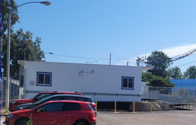
SDHS temporary office


Student Drop-off and Parking

There is ample student parking in the Inspiration Point parking lot with direct access to our campus over the pedestrian bridge. This is the recommended location for student drop-off. It is a also good option for parking during school/evening events.

SDHS Parking Options

The back gate will be locked during the school day. Visitors and students returning from appointments during the day should enter the campus via the main office on Park Blvd. There is limited street parking on Park Blvd.

Public Transport

Many of our students use public transport to get to school, and this is also a good option for visitors. We are on three major San Diego Metropolitan Transit System (MTS) bus routes, with buses arriving every few minutes. The City College trolley stop is 7 minutes walk away.

Downtown trolley map

Campus Map

Campus map with room numbers, 2023 SDHS Campus Map with room numbers

Download this map (pdf)


Find us on google maps here

Find us on google earth here

Our location


Website by SchoolMessenger Presence. © 2024 SchoolMessenger Corporation. All rights reserved.